Dues are Due!
The Chapter needs your dues. We have been very active this year so far, but we have lagged in getting out the word to update your dues.
Newsletter of the Central Coast Chapter of the California Land Surveyors Association
The Chapter needs your dues. We have been very active this year so far, but we have lagged in getting out the word to update your dues.
by: Tucker Sanders P.L.S.

I was born and raised in Atascadero, CA where I grew up playing baseball, basketball, soccer, golf, and tennis while squeezing in fishing when I could.
I was lucky enough to grow up in a household where my father was a Land Surveyor, so I was exposed to the profession at a young age. I helped a couple days off and on during summers growing up mostly running a star drill for nails and tags. I have fond memories of the crew seeing how many pieces of rebar they could sneak into the lath bag every time I set it down before I noticed.
My first real job was working at Tackle Warehouse in San Luis Obispo due to my love of fishing. I really had no plans to go into the Land Surveying profession and was initially interested in pursuing a degree in hatchery management. I ended up deciding to give Land Surveying a shot as I enjoyed the outdoors so much and always excelled at math.
I visited Fresno State my senior year of high school and decided to enroll in the Geomatics Engineering program after a great tour with Dr. Crossfield.
I enrolled at Fresno State starting in the Fall of 2008 and graduated in the Spring of 2012 with my Bachelor of Science in Geomatics Engineering.
During my time at Fresno State, I played for the Fresno State Rugby team from 2008 to 2009. I worked as an equipment manager for the Geomatics Engineering Program where I oversaw weekly maintenance and cleaning of the survey equipment as well as setting up and networking computers for our computer lab. I was also a president of the Student Association of Geomatics Engineering at Fresno State. I was also an inductee into Lambda Sigma, the honors society for Geomatics Engineering at Fresno State.
I was lucky enough to have a paid internship with the Bureau of Land Management out of the Paso Robles Field office during summers while going to Fresno State. We worked predominantly on a project in the hills outside of Solvang but were also lucky enough to do a bit of work on the Santa Susana Field Laboratory. Working for the BLM gave me a truly great foundation on the principles of Cadastral Land Surveying.
Out of college I worked for a company based out of Madera, CA called Bedrock Engineering. I was very fortunate for all the surveyors I was able to work with here and the knowledge they passed down. I spent 2 years almost exclusively in the field working on anything and everything.
After a couple of years of working full-time in the Central Valley I came to the conclusion that I wanted to move back to the Central Coast. I was approached by Vollbrecht Surveys out of San Luis Obispo in early 2014 and took the opportunity to move back to my hometown. One of the more unique opportunities I had while working for Vollbrecht Surveys was to build 3d airspace models of airport layout plans for the airports the company was specializing in at the time.
In January of 2015 I made the move to North Coast Engineering, Inc. where I was lucky enough to work under my dad for the remainder of his carreer. During my time at North Coast Engineering, Inc. I have progressed my way from Survey Technician to my current position of Principal Land Surveyor which I officially took over for my dad when he retired in January of 2021. I am currently licensed in CA, ID, AZ and am hoping to add a couple more adjacent states as well as pursue my cFedS in the next couple years.
I consider myself very fortunate to be able to live and pursue a career in the beautiful Central Coast and make a conscious effort to never take that for granted.
Spring and early summer are the times in California when there is the greatest chance of getting Lyme Disease.
We are lucky on the Central Coast as the number of cases is relatively small: from 2001 to 2023, San Luis Obispo County has had 26 cases, and Santa Barbara has had 66 cases. Still, as we are a profession that often works in rural areas, we land surveyors should be conscious of the symptoms of Lyme Disease and Alpha-Gal Syndrome (AGS),the second most common major disease caused by tick bites.
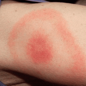

For those of you working in the rural areas, the California Department of Public Health has good general page on Lyme Disease which can be found here: Lyme Disease. Please take some time to review if you have any concerns about Lyme Disease.
Currently Alpha-Gal Syndrome (AGS) cases are rare in California and in the western states. There is some confusion in reporting AGS, because there is only an emerging understanding of AGS. In an article published by Tick-Borne Conditions United titled “Alpha-Gal by the Numbers: A comparison of Lyme, AGS and other tick-Borne disease cases from 2017-2021”, only a few southern and eastern states were listed as having had cases. In a CDC report titled ” Geographic Distribution of Suspected Alpha-gal Syndrome Cases — United States, January 2017–December 2022” the geographic distribution map shows a small number of suspected cases on the west coast, including San Luis Obispo and Santa Barbara Counties. Both articles have links to sites with more information on AGS. The lone star tick is a vector for AGS, but is only reported in the eastern, central and southeastern US.
As we all know, it is a good idea to check yourself after being out in rural areas, as it is always best to remove any ticks immediately even if that means thinking you feel them crawling over you for the rest of the day!

See OSHA Fact Sheet for more information about exposure to Disease-Carrying ticks.
This is our first of many (?) challenges to the surveying community, especially the younger ones. Below is a question from a Trig-Star test. If you are up to the challenge, see if you can solve the question.
RULES: You may not use any CAD or Graphic program/app. You may use paper and pencil, calculator and even a spreadsheet. Do not get online to A) find the answers 2) find a site that will solve for the answers.
First person who submits the correct answers (all must be correct) to the Central Coast email: central.coast.clsa@gmail.com will win the following prize: (to be determined, but it will be amazing!!)
In the event of a tie, the submitted answer that best explains how the problem was solved will win. The determination by the judge is final. No chapter officers may participate.
For your assistance here is the formula sheet given to the participants: Formula Sheet
Distances to the nearest hundredth.
The solution will be posted once we have a winner.
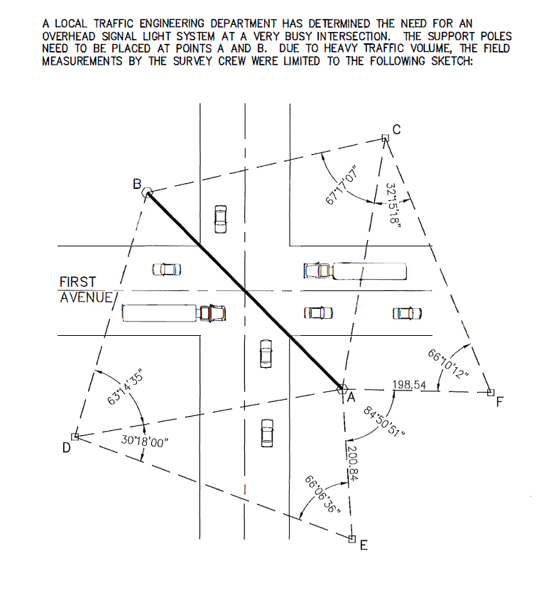
Distance AC = _____________________________________
Distance AD = _____________________________________
Distance DC = _____________________________________
Distance BC = _____________________________________
Distance AB = _____________________________________
In last month’s article “Surveying Apps?!?” I wrote about the phone apps that imply they can find your property lines/corners as well as I provided a link to a realtor that talks about how you can use these apps to get your corners and that they are close enough for most work. As I mentioned in that article some of these apps can be of limited benefit, just not to a homeowner wanting to set their property lines.
This month I was curious about what “serious” articles said about establishing one’s own property boundaries. I went about it in the same way I went about in finding “Surveying Apps?!?” which was asking the question “How do I find my property lines?”. I stayed away from indicating that there were any boundary disputes, as that would just bring up attorney websites (maybe next article).
First, I ignored the links to the surveying apps and skipped the links to companies that only provided record information about properties. I was looking for some definitive instructions on how I could establish my property lines and do it as cheaply as possible while still being 100% accurate.
I ended up reading articles from Forbes, REDFIN, U.S. News and World Report and Bob Vila. For those of you who don’t know who Bob Vila is, he was the original host of “This Old House” and over the years showed me how every DIY project I did, I did wrong. I still get up early on Saturday mornings to watch it (apparently to the shame of others).
All four articles took a serious approach to establishing property lines within their writings. There are links to the articles below, which will give you, a land surveyor, a good understanding of what your potential clients might be thinking when they call you.
“My surveyor said he was here on Monday, but I only saw him in my yard for five minutes. What is the deal?”.
The Forbes article “How to Hire a Land Surveyor: Checklist and Tips” was the one that clearly was telling the reader to hire a land surveyor, no ifs, ands, or buts. The article indicated when you need a land survey. I believe it made it clear, although not complete that if you are reading the article, you need a land surveyor. It discussed land surveyor qualifications, how to hire a land surveyor, questions to ask a land surveyor and land surveyor red flags. Two interesting items about the articles, the breadcrumbs showed that it started under “home Improvement” then to “Lawn Care” then to “How to Hire a Land Surveyor”. I am hoping that it is linked to other areas in the site, beside lawn care. Also, they had a short (FAQ) at the end and the last question was “My surveyor said he was here on Monday, but I only saw him in my yard for five minutes. What is the deal?”. That does seem to cover a common question clients have. The one sentence answer said the surveyor is probably doing research around the block or further.
Redfin had the best title: “How to Find Your Property Lines: Fast, Easy, and Precise”. That title will surely attract interest. The article begins by explaining why it is important to know your property lines, and what types of projects might require knowledge of your “true” boundary. It does say that land surveyors establish formal boundaries. Then it goes into 11 ways to find your property lines. The first option is to use Google Maps. It says if you zoom down far enough you will see the property lines “unless that feature is not accessible in your area”. I have never seen property lines on google maps. I tried a number of states and never saw property lines pop up. The second option was to hire a licensed land surveyor. To be helpful the article indicated that a typical boundary survey costs between $330 and $670, unless you have some strange property and then it could cost up to $1000. The remaining methods are:
I was not a big fan of the Redfin article in that it was misleading and confusing. (But, hey, how hard can it be?)

On to U.S. News and its discussion of needing a survey. First the article does tell the reader to not trust driveways, fences or gardens as accurate guides to the boundaries. It was implied that a mortgage lender or title company will require a survey (not my experience). Then there are some recommendations on options “before you fork over the cash for a new survey”. The options are reasonable; check your deed, review a plat map, spot survey markers, search for survey pins. I am not quite sure what they believe the difference is between a survey marker and a survey pin, in that both may be hidden.
U.S. News then discusses hiring a surveyor if all else fails. The article offers that a survey in a relatively recent subdivision takes 30 to 45 minutes but in older neighborhoods a half-acre could take two to three hours, these numbers are based on a land surveyor in Alabama. It says the national average for a survey is $542 but could cost more than $1000 depending on the size of the property.

The search returned this article title “How to Find Property Lines – 9 Easy Tricks”. This is the second-best title for drawing in the audience. It first discussed what a property line is and how it can be bad to guess where it is if building anywhere near the line. Here are those 9 easy tricks:
All in all, these articles do try to make it clear to readers that sometimes there is a need to hire a land surveyor. Some of the articles place more emphasis on that need, but they all make it clear that sometimes, especially if there is a dispute, a land surveyor must be called in. I think for the most part these articles are helpful to readers trying to determine what to do to find their boundaries. I don’t think it is a problem for a reader to try some of the other options when they just want to know where their boundaries are. The articles make the reader aware of land surveyors and the professional skills that surveyors provide.
The United States has a wide range of available information with at least 50 states that all want to do things their way. So, it would be impossible for one of these articles to address all the variations in the states on the best ways to get available information on the reader’s boundaries. That said, they do give a good starting point for interested readers. However, for those of you that get a call from a reader of one of these articles, you may have a hard time explaining why your fees are above the national average.
– Dawn Weinberger, CorinneTynan. “How To Hire A Land Surveyor: Checklist And Tips”, Lexie Pelchen, . Forbes Home Online, https://www.forbes.com/home-improvement/lawn-care/how-to-hire-land-surveyor/. Accessed 30 May 2025
– Lexi Klinkenberg. “How to Find Your Property Lines: Fast, Easy, and Precise”, REDFIN Blog, https://www.redfin.com/blog/how-to-find-property-lines. Published 29 August 2023. Accessed 30 May 2025.
–Josephine Nesbit. “How Do I Find My Property Lines?”. Lisa Rajala, Dawn Bradbury, U.S.News & World Report/REAL ESTATE, https://realestate.usnews.com/real-estate/articles/how-do-i-find-my-property-lines. Published 20 May 2024. Accessed 30 May 2025
Bob Vila, Glenda Taylor. “How to Find Property Lines”. bob vila, https://www.bobvila.com/articles/how-to-find-property-lines. Updated 24 January 2022. Accessed 30 May 2025.
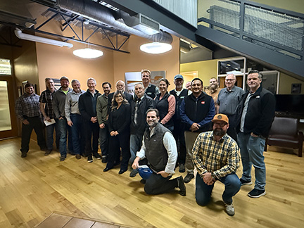
On Wednesday March 19, 2025 the Chapter meeting was held at and sponsored by the Wallace Group. The meeting packed their large conference room to overflow capacity. Wallace group provided drinks and an all you could eat taco dinner with all the trimmings! Donations were taken up for the scholarship fund and to support student attendance to the CLSA Conference.
While we feasted on the provided dinner, a lively business meeting was punctuated by the volunteerism and support of the chapters Monument Conservation Committee discussion. It almost became a bidding war when talking about support of the committees proposed luncheon for agency engineers to explain their role in monumentation conservation. Committee Chair Robert Reese explains more in his post that can be read here.
The speaker for the night was Jay Seymour, president of the California Land Surveyors Association in 2015. Mr. Seymour, a licensed surveyor for 47 years, gave a heartfelt talk on the land surveying profession and how the future of the profession is in the hands of the profession itself. He is a very enthusiastic and positive role model for all of those interested in the profession.
A big THANK YOU goes out to the Wallace Group for this meeting. It is a model that other firms should consider in supporting the profession!